Each map defines different location entities depending on the map. The names of these entities must match location names in your data for the values to display correctly. Check with your database administrator if you need assistance to find your location data. Each map is made up of smaller location entities. For example, a world map displays continent entities, a map of Europe displays country entities, and a country map displays different entities such as provinces, counties, regions and states, depending on the structure of the country. Each location entity displays numeric and color values using values from your data source.
After you match location data to the location entity of the map you select a value to display on map locations.
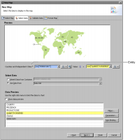
Figure 18‑4 shows an example of the Select Data page.
Figure 18‑4 Showing available data to display on the map